Tuesday, March 13, 2012

City Forecast Discussion: Albuquerque, New Mexico


Here is a gorgeous site of a desert city.  The Duke City is truly a unique location with it's city life and hot air balloons.  The weather here is just as unique as the city itself.  The trickiest part of forecasting for Albuquerque is the wind speed which highly influences the temperature for the city.  Here is an aerial map of Albuquerque.
It sits in a valley to the west of Sandia Mountains and Manzano Mountains both of which are over 10,000 feet at their peak.  Albuquerque rests about 5,300 feet above sea level, but the precise location that was forecasted for is 5,355 feet above sea level at the Albuquerque International Sunport which is indicated on the map with the blue and white airport symbol next to Interstate 25.  Earlier I mentioned that wind played a huge factor in the weather here esp. with the temperatures.  Here is an image to explain why.
The arrows point to Interstate 40 which separates the Sandia and Manzano Mountains.  With the interstate being there, any easterly wind will travel along the valley it lies in and accelerates the wind speed.  The airport lies just directly west of this valley and can experience some very strong winds.  One day during the forecast period the strongest sustained wind was 55 mph with a gust of 68 mph.  Those kind of winds are found in a strong tropical storm!  Not only are the easterly winds stronger than winds from other directions, they can also warm the city as the air descends the mountains and travel into the city.  This can make for a warmer high and low.  Clouds always play a factor when forecasting for any city, but this time the geography played a big influence on clouds.  There was a day where clouds stayed over the city for several hours although there wasn't much instability to create them.  It was all due to orographic lifting, i.e. winds pushing air up a mountain, cooling the air until saturated forming a cloud, and then pushing it off the other side of the mountain.  This effect was due to all the mountains to the west of Albuquerque.  When that occurred, the temperature couldn't warm up as much as it could have and also didn't cool off as much is could have.  Since Albuquerque is an arid location, rain wasn't much of a factor as none of it accumulated during the forecast period.  However, precipitation does fall over the city, but due to strong winds and a very warm and dry surface the precipitation, rain or snow, typically evaporates or melts before ever reaching the ground.  This was highly noticeable on one of the forecast days where snow fell, but quickly evaporated due to the strong, dry easterly winds and the dry air near the surface.  With that in mind, it can influence the temperature through evaporative cooling, i.e. cooling the air through evaporation, and cooling the air off.

Overall, a very difficult city to forecast for if you are not acquainted to mountain weather.  The next location is going to be almost as challenging as Albuquerque.  It rests next to the tallest mountain in the world from its base to its peak and located in the most southern state in the United States.  Here is a big hint, hulas, luaus, and leis are very common and traditional for this spot.

Monday, March 12, 2012

Spiralling March Madness

March Madness

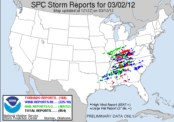
March arrived with a big entrance this year.  As fierce as the basketball competition is this year for the NCAA, the weather created more of an uproar than the NCAA did.  March 2-3 was one of the largest March tornado outbreaks in recorded history.  A total of 1,010 preliminary storm reports were recorded most of which were recorded on March 2nd.  Of those 1,010 reports 175 of them were tornado reports, 364 were wind reports 10 of which were confirmed to be 65 knots or greater (75 mph or greater), and 471 reports of hail which 52 of them were confirmed to be 2" and larger.  As mentioned in the 2012 Leap Day Tornado Outbreak these preliminary reports are not the actual total of tornadoes, wind damage, and hail.  Just the number of reports that have been called in from either trained storm spotters, law enforcements, and/or any other citizen.  Here are the images of the reports for March 2nd and March 3rd.120302_rpts Reports Graphic120303_rpts Reports Graphic

What has been confirmed so far is 61 tornadoes stretching from the Ohio River down to Florida.  The confirmed amount is mentioned on Wikipedia.  Out of the 61 confirmed tornadoes 18 of those were EF0 (65-85 mph), 16 EF1 (86-110 mph), 16 EF2 (111-135 mph), 9 EF3 (136-165 mph), and 2 EF4 (166-200 mph).  This event was accurately forecasted ahead of time and warned heavily as the following image shows all 654 warnings that were issued, 279 of them being tornado warnings. Tornado Outbreak As It Happened

Pretty impressive amount of warnings for just one day.  Unfortunately, with all the warnings and lead time there were still 41 deaths that were confirmed making this outbreak the second deadliest in March on record.

The two EF4 tornadoes were reported in Kentucky and Indiana one around the Crittenden, Kentucky area and the other carved a path from Fredericksburg, Indiana to Bedford, Kentucky where Henryville, Indiana was in the middle the path and nearly whipped out.  Here is a radar image of the Crittenden tornado:

The spiral with the small yellow orange spot is where the center of the tornado is.  What is really fascinating is to see such a large rotation within that storm without any precipitation interfering with the image.  Here is a radar image of the tornado that was in southern Indiana and moved into Kentucky:

You can see New Perkin within the green colors and the tornado is just southwest of that where you see shades of pink in a near ball-shape.  That ball shape is known as a debris ball.  To see full details and images of this tornado go to the following site: http://www.crh.noaa.gov/Image/lmk/03022012_EF4.htm

Tuesday, March 6, 2012

A Rare Leap Day Year?

Leap years are one of those unique years that add a day to a typical year so most of us either think of   OR  .

A leap year will come every 4 years with a leap day so what can make this leap years leap day a rare one?  This!!! 

The 2012 Leap Day Tornado Outbreak was one for the history books due to its intense tornadoes and the time of year that it occurred.  It began February 28th in Nebraska and ended in the Virginia's on February 29th.  A two day total of 434 storm reports were recorded with 48 of the reports to be tornadoes, 293 to be wind damage, and the remaining 93 to be hail reports.  Keep in mind that a lot of these reports are reported from the same storm at the same location so there are always more storm reports than what actually happened.  Wind and hail reports are hard to clean up and separate, but tornadoes can be easier to separate from the actual number of tornadoes to the number of reports.  So far there has been 40 reported tornadoes from this event and 39 of those have been confirmed with the strongest being an EF4 in Harrisburg, IL.  The overall rankings of these tornadoes are 7 EF0, 13 EF1, 16 EF2, 1 EF3, and the Harrisburg EF4.  Unfortunately, with the number of tornadoes that occurred and most of them during nighttime hours there has been 13 deaths confirmed.  Like all situations though, there is the bright side where there could have been more deaths, but due to today's technology and great lead time for warned places more lives were saved.

Now one question stands out, is this the only memorable leap day?  Of course not!  Back in 1748 on February 29 some of the heaviest snow fell from the "Winter of the Deep Snow" leaving Salem, MA along the coast with more than 30 inches of snow.  In 1952, three tornadoes tore through Tennessee counties of Marshall, Lincoln, and Warren leaving behind 166 people injured and 4 dead.  In 1988, southern California was in the spotlight with heavy rain where 4.67 inches fell in Ventura County at Tommys Creek.  Other parts of the U.S. was dealing with record high temperatures.  In 2000, Rapid City, SD broke a city record for the longest consecutive number of the days without falling below 0 which was 421 days on February 29th.  It's previous record was 362.  Most recently in 2008, The world's tallest snowwoman was revealed in Bethal, Maine named "Olympia".  She stood an astonishing 122 feet and 1 inch tall and weighing an amazing 13,000,000 lbs or 6,500 tons!