2011 is coming to an end as New Year's Eve approaches and shortly after the infamous 2012 begins. Your 2012 forecast is that everything you have seen about the world ending is true. Just kidding! Even though the Mayan calender ends on 2012 it is unlikely that the world would end. What we can look at is how other years have ended and began. Going all the way back to 1947 where the 1947 New Year's Eve Tornado Outbreak occured. A year that ones during that time will never forget for the end of 1947 and the beginning of 1948 where 11 tornadoes tore through the Southern U.S. and unfortunately taking 256 lives from entering 1948. On the bright side, 20 people were spared with injuries to live to tell of the great devastation. Now moving to a much more recent tornadic event in 2010 when the 2010 New Year's Eve Tornado Outbreak occured in Oklahoma, Arkansas, Missouri, and Illinois from Dec. 31 to Jan 1. As many as 36 tornadoes touched down with the strongest being an EF3. Unfortunately, 9 lives were lost from this outbreak, but due to the vast advancements on tornado warnings and preparation ONLY 9 lives were lost and not large numbers like in 1947.
Now you are probably expecting a list of blizzards on New Year's Eve or New Year's Day. Well, as far as recorded history shows there hasn't been any and the same thing goes for significant Nor'easters, but tropical systems is another story. None have made landfall during this time here in the U.S., but it is always good to notify that hurricanes and tropical storms do exist around that time of the year. Back in 1954, a storm in the Caribbean Sea developed and eventually became a hurricane known as Hurricane Alice and passed over the Leeward Islands. It developed on Dec. 30, 1954 and died of on Jan. 6, 1955. Almost exactly 51 years later another storm developed on nearly the same day as Hurricane Alice did. During the historic and memorable 2005 season a storm developed on Dec. 29, 2005 and developed into Tropical Storm Zeta, the 30th named storm of that season which is record for the most tropical cyclones in a hurricane season on record. Tropical Storm Zeta caused no damage to islands as it was a fish storm. It eventually died off on Jan. 6, 2006.
It is known that New Year's Eve and New Year's Day are not really recognized as a holiday where great weather events occur, but as you have noticed anything is possible regardless of what time of the year it is. What kind of weather will New York City have when the ball drops to end 2011 and begin 2012? It is a far forecast, but for those who want to travel to Manhattan and stand in Time Square to see the beautiful 11,875 pound, lighted, crystal ball to drop the weather won't be too bad. So far it is looking to be in the upper 30's when the ball drops at midnight with partly cloudy skies and winds coming from the NW at around 5 mph. New York City isn't the only location in the U.S. that is dropping something though. I have read of foods, fruits, musical instruments, leaves, shoes, disco balls, animals, flowers, jugs, sea creatures, beach balls, and many, many more things to drop at midnight in a number of locations around the U.S. If you want to know more about it and what they are, go to the following link and find out. http://en.wikipedia.org/wiki/List_of_objects_dropped_on_New_Year's_Eve
Tuesday, December 27, 2011
Sunday, December 25, 2011
The Spirit of Christmas Past

A Merry Christmas to everyone of all nationalities and all locations. Some of us had a beautiful white Christmas with falling snow and/or snow on the ground and some of us didn't, but since this year what other sort of weather has people encountered for Christmas? Not in any order of year, but in type of events that will be mentioned of the spirits of Christmas past. Christmas in 1982 is known as the Christmas 1982 Tornado Outbreak for people in the Central-Southeastern U.S. as a system spawned 18 tornadoes from Dec. 23-25 with 3 lives lost. Luckily, tornadic events are not very common around Christmas time, but blizzard events are a little more common. The North American Blizzard of 1947 sprawled snow all over the Northeast Region of the U.S. dropping as much as 26 inches of snow in Manhattan at Central Park. Snow started falling on Dec. 25 and steadily and silently fell through Dec. 26. As harmless as it sounds it left devastation behind by taking away 77 lives. A much more recent blizzard event was the December 2010 North American Blizzard. Considered as a historic blizzard dropped as much as 34 inches of snow in and around New Jersey. It affected the entire Atlantic Coastline with showers and thunderstorms in Florida to blizzard conditions in the Northeast. This was one of a few storms that had the rare phenomena of thunder snow in it. Was Jim Cantore there I'm not sure, but if he was he probably would have reacted like he did in early 2011 when he experienced it in Chicago.

Amongst the nearly 3 feet of snow that was dropped and the howling winds that came along with it, this blizzard caused a pretty penny worth of damage rounding to $60 million and left behind 7 to perish. It originated on Dec. 22 and didn't finish causing havoc for the U.S. until the 29th. Other notable storms was the Christmas 1994 Nor'easter that formed Dec. 22 and ended on the 26th. No snow or ice was reported from this storm, but it intensified rapidly to an amazing 970mb storm creating problems from the Southeast to the New England area. Southeast experienced heavy rainfall with over 5 inches of rainfall and windy conditions along the Atlantic Coastline causing massive beach erosion from the Carolinas to Massachusetts. More than $20 million of damage was caused by it and 2 lives were lost, but luckily no other lives were taken.
This is a list of some of the most memorable weather events on Christmas. As weather recording has only be going on for abour 150 years for most places a lot of events cannot be taken into account and ones that were small but leaving big impacts on families were included either as they hard to track down. I hope everyone has a Merry Christmas regardless of where you are.
Thursday, December 15, 2011
City Forecast Discussion: Erie, Pennsylvania
A city that sits in the Northeast right on Lake Erie is the beautiful city of Erie. A peaceful city with an old-fashion sense to it with beautiful country sides and beautiful neighborhoods. Too bad the weather cannot be explained the same way. Erie is as tricky as Miami and Juneau for forecasting since it sits right next to a body of water. Every factor in the air plays an important role in determining how warm, cool, windy, dry, or wet it will be. The temperatures for the city is highly dependent on the wind. An important thing to keep in mind for Erie is that the highest sustained wind for each day is rather uncommon to go below 10 mph. If the wind blows from the land to Erie it will warm up and cool off as the rest of the land warms and cools. When the wind does this it has been noticed that Erie will reach its warmest and coolest days. If the wind blows from Lake Erie then its a different animal. Erie will have more of a small temperature change with winds blowing from the lake since before winter really kicks in it stays unfrozen. From experience, there was a day where the high reached 41 and the low was 38 with the wind coming off the water that entire day. That is only a 3 degree temperature change for an entire day. Quite crazy. Clouds were in the area, but the clouds primarily affect the temperature of the city if the wind is coming from the land blowing towards Erie. Clouds have little affect when the wind is from the lake.
Precipitation amount is just as challenging as the high and low for Erie. It boils down to how far north or south the low pressure system is, how cold the air is, and the direction it is moving with respect to wind. Because of Erie's location it typically gets a piece of most systems that near it, but sometimes a low pressure system may not be near it and they will still receive rain or snow. How is that? An interesting phenomenan called lake effect. It can be in the form of rain or snow, but most of the time it will be in the form of snow. Snow is a funny and tricky form of precip to forecast for. Not really in its form, but how much will fall and converting it to liquid. Typically, you can use a 1:10 ratio meaning for every 1 inch of liquid water there will be 10 inches of snow and vice versa. This however does not always follow through as it can be as little as 1:5 or as much as 1:50, figuratively speaking. If this isn't tricky enough then keep in mind that if there were lake effect snow or rain it doesn't mean it will fall over Erie.
Finally, the wind is always hard to predict no matter what city you are in, but Erie is a little different. Wind from bouys in the lake can be as high as 30 to 40 mph sustained, but just on land it could be 10 to 20 mph all due to friction. The Erie International Airport is very close to Lake Erie, but there is still enough land to create enough friction with the wind to slow it down some. For the short period of time that Erie was forecasted for the wind ranged from 13 to 22 mph depending upon how tight of a pressure gradient there is and whether the wind is coming off the water or land.
Overall, very tricky forecast city with the 2 weeks spent on it which allows for high respect for the meteorologists forecasting for the area. Now Christmas break is in session and will have a resting period until the next forecast city starts in late January. Here is a hint: It is known as The Big Easy and not located in any county, but another kind of geographic subdivision of a state; well known for a French phrase that occurs on a Tuesday every year before lent starts; and well known for a very famous street that has the same name as a type of whiskey.
Thursday, November 24, 2011
Thanksgiving and It's Weather Past

These are only some of the memorable weather events that could be found without deep research. Since Thanksgiving has been celebrated for almost 400 years it's hard to keep track of every event that occured. One thing is for sure though. The weather that was experience on the first day Thanksgiving was celebrated is nearly impecable to what it looks like now in the U.S. When the English settlers and Wampanoag Indians gathered for Thanksgiving they enjoyed 3 straight days of nice weather which was perfect since their Thanksgiving feast lasted that long. Look at the current radar for the entire United States.

Besides parts of California, Western Washington, and a some patches of snow in Oregon, Idaho, and Montana and spoty showers in Southern Florida this could look fairly identical to what was experienced 390 years ago. Expect most of the places with no precipitation around them today to persist for almost 3 days. Happy Thanksgiving!!
If you would like to look at some of these events in more detail visit this website. http://www.earthgauge.net/wp-content/EG_Thanksgiving%20Weather.pdf
Wednesday, November 23, 2011
City Forecast Discussion: Juneau, Alaska

One of the most beautiful cities due to is location near 5,000 ft mountains, glaciers, and beautiful cool Alaskan waters. The most northern city in the forecast contest was, as you can guess, the hardest to forecast for. It was one of those cities that everything possible that has been mentioned in previous cities played a factor in temperatures, wind, and precipitation and at the same time those things didn't play a factor. The image above shows downtown Juneau which is a little ways away from the airport which is at the foot of the distant mountains in the background.
Starting off with the temperatures, they typically don't vary from day to day with stable conditions in Juneau. A typical range from the high and low is 5 to 8 degrees Fahrenheit. When low pressures and fronts are passing through the area then all bets are off. Winds play a big factor because if the are from the any direction from the NE to the E then the winds are coming down the mountains which would result in some warming of the air, but due to the mountains being covered in snow and a glacier to the north of the airport that just keeps temperatures rather steady. If winds come from a westerly direction then they are coming off water that is sitting around the low to mid 40's. Winds from the south come off a mountain over water and then onto land. Needless to say when trying to contribute direction of wind and temperature with Juneau it's just too hard to figure out. Clouds have a big factor, but like wind it's not a good indicator of how much it will warm or cool. One night it was clear with snow on the ground and you would think the temperature would drop with calm conditions. Well, the temperature slowly fell throughout the night with no mixing of the air. Strange huh?
Wind is a whole different story. Juneau is known to have very gusty winds and its reputation still holds, but trying to forecast how high it will get is nearly impossible. Stations around the Juneau International Airport would gust to 40 or 50 mph and the airport could get winds of 12 or 13 mph and the opposite can happen too. The terrain has a lot to deal with that, but how can you see that to forecast it is hard. Finally, precipitation is just as difficult as the other things. Due to some mountains reaching as high as 3,000 to 4,000 feet south of the airport and a number of large high elevated islands west of it, it really makes a huge impact on how much precipitation falls. Another thing is the precipitation, at this time of year, is typically a mix of rain and snow and accumulates very slowly if any when it does that.
With all of this in mind and keeping in mind that some models have a hard time forecasting for Juneau since it rests on the outskirts of their range, it is truly a diffucult city to forecast whether you live there all your life or have never set foot in the city. Fortunately, forecasting for this city is done and now on a break before the next forecast city starts. This city is primarily known as either The Flagship City or The Gem City and rests on one the five Great Lakes.
Thursday, November 10, 2011
City Forecast Discussion: Dayton, Ohio

The city of Dayton, OH is a big city with an interesting history to it. Weather plays a big role in that history as much as anything else does. Forecasting for this city was rather challenging. It may not seem like it since there are not any local effects such as mountains, bodies of water, or valleys. The only thing that is left to affect the city is larger scale effects such as clouds and fronts. The main determining factor for the temperatures is the wind. You might think that the sky conditions would cause some variability in the city and it does to a point. The speed and direction of the wind was such a key factor that it literally determined your high and low more than clouds did. If winds were light in any direction then it practically had little to no effects on the temperature. If winds reached and exceeded 6 or 7 mph then the direction was key on how warm or how cool it would make the city. To add on to the challenge of Dayton is its location. It is in a prime spot to be affected by mid-latitude systems. Most fronts that drive across the Eastern U.S. will impact Dayton whether it receives a lot of rain or only a little.
The next forecast city is fair away from this city and much further north. It is the capital of The Last Frontier state that has the longest shoreline than any other state of the U.S. and this state holds Mount McKinley, the highest mountain in the U.S.
Friday, October 28, 2011
City Forecast Discussion: Riverton, Wyoming

The beautiful and high city of Riverton, WY is a small city of over 10,000 people has the delicate appearance of a peaceful, tranquil city. However, the weather is anything but the appearance of the city. If meteorologists thought forecasting for Miami, FL was difficult then they should be introduced to this city that ranges from around 4,500 feet in the city to 5,500 feet at the airport. So, what makes this city so difficult? One word, wind. Wind played a factor for Miami as well, but not to the magnitude of Riverton. Why wind plays a big roll is because of the terrain. To the west and southwest of the city is the states highest mountain range reaching over 10,000 feet. To the north is a high plateau that is around 7,000 feet and to the east the elevation declines as it gradually slants down into The Great Plains. What does this mean for the wind? Good question. If a wind blows from the west or southwest then it will warm rapidly warm the city up. If the wind blows from the north it gradually warms the city up. If a wind from the east occurs then it would cool the city down or keep the temperature from warming much if any. Do clouds make a factor when the wind is blowing? From the two week experience in forecasting for the city clouds will not make a difference in how high the temp goes when the wind is warming it up. Overall, another difficult city with lots of learning experiences to hold on to for future forecasting cities and future forecasts.
The next city that is currently being forecasted for is known as The Gem City with the motto of "Birthplace of Aviation". Can you guess what it is?
Thursday, October 6, 2011
City Forecast Discussion: Miami, Florida

The Magic City as some call it, the city of Miami is a beautiful and exciting location to be in. The largest city of Florida holds its beauty in a number of ways depending upon your preference. Unfortunately, forecasting for a city of this magnitude is a big challenge to meteorologists. As versatile as the city is, so is the weather. A number of factors come into play when trying to forecast for one of the largest cities in America along the Atlantic Coast. The high and low temperature is always a challenge to forecast for in Miami. A few things to keep in mind on how temperature can change and that is wind speed, wind direction, and sky cover. When in Miami if there is a wind coming from a westerly direction, the temperature of the city will be slightly warmer because the winds are blowing the warm air from the land over the city. If there is an easterly wind or northerly wind the temperatures will be slightly cooler due to influences of the water temperature. Sky conditions have a huge impact too upon the city. If it is clear at night, the temperature would cool off quicker than if there were clouds overnite. If clear during the day, the temperature warms up much quicker than clouds hovering over the area. The clouds will prohibit much heating during the day while at the same time it will prohibit much cooling during the night time. Wind will also effect the temperature regardless of clouds in the sky or not. Those three factors are prime sorces of why Miami is so difficult to forecast, despite its size.
For all those that live in Miami or want to visit Miami keep those factors in mind when planning your day or your vacation. Be aware of your wind speed and direction and the sky conditions. Have a little fun and check on the local broadcast meteorologists and see if they are taking those factors into their forecast.
After spending 2 weeks forecasting for Miami, it was fun and, as I have described earlier, challenging due to those 3 main factors. As the forecast for Miami ends this week, a new journey begins for forecasting for the city that is home to the Brunton compass and was featured in "Brokeback Mountain", Riverton Wyoming.
Monday, May 23, 2011
May Month Awakening?
What do you know of a typical month of May? It is normally very active in the weather category with numerous tornado reports and even more wind and hail reports, but this May has been rather boring.

That is until last weekend. Here are the storm reports for Saturday:
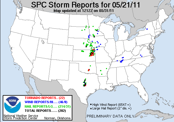
And the storm reports for Sunday: 

Looks like May is trying pick up the pace to hold on to what it is historically known for. Sunday's events is already holding a record for itself. Not in the number of tornadoes or number of storm reports, but because of a tornado that struck a city with a population of over 50,000 called Joplin, MO. It took a direct hit with a very intense, unrated tornado that has so far killed 89 people as of the morning of May 23, 2011 making it the 21st deadliest tornado in recorded history. To get a better idea of the damage, go to http://www.buzzfeed.com/mjs538/devastating-pictures-of-the-joplin-missouri-torna.
With what happened yesterday should we expect something similar for today? As it is nearly impossible to predict an exact perfect setup as was seen yesterday, we can definitely predict whether things will be simliar. Unfortunately, things are looking like they will be similiar to yesterday, just in different areas. Here is SPC's convective outlook for today: 
The moderate risk over Oklahoma, SE Kansas, and SW Missouri holds the highest risk for tornadoes (10%) and hail (45%). This area also holds the highest percentage of significant hail. The other area of moderate risk holds a risk of hail as well (30%), with the possibility of it being significant, and a high chance of strong, damaging winds (45%). Keeping that in mind and looking at the NAM and GFS models, here is my forecast for severe weathering using the SVRPROB:

I have highlighted similar areas as SPC did, but I have noticed some important factors in severe weather in lighter shade of red areas that I will watch for because of multiple layers of lifting and very high CAPE values. Where I found areas of the most instability is where I have the high risk areas. These areas are located in an environment of high CAPE, little CIN, lifting in upper, mid, and low levels of the atmosphere, abundant moisture, and areas where the surface winds are nearly perpendicular to the winds in the mid-layers of the atmosphere. All of this pretty much brews up perfect conditions for long-lived tornadoes and large hail as long as no other factors prevent it from happening. Storms have already formed and dropped lots of rain over NE Oklahoma, extreme NW Arkansas, and SW Missouri which will prevent further severe development for the time being, but the areas I have highlighted in a high risk have not seen anything yet and still getting peaks of sunshine, which will only exacerbate the situation. The darker shades of red is where storms will likely develop overnite.
Overall, keep a sharp eye on the highlighted areas, esp. the ones in a high risk area in the SVRPROB and ones in the moderate risk by SPC. Stay safe and be alert.
Saturday, May 21, 2011
Great Mississippi Floods: Which is Worse?
Within one century, between 1912 to 2011, there has been 3 major floods of the Mississippi River: The Great Mississippi Flood of 1927, The Great Flood of 1993, and The 2011 Mississippi River Flood. All of these major flood events have been devastating, but which one is actually worse?
The Great Mississippi Flood of 1927 held the record for the most destructive river flood in the history of the United States. It filled the tributaries in Kansas and Iowa to the max capacity and caused the Cumberland River in Tennessee to top its levees to a record height of 56.2 feet. The flooding was so bad the it broke the levee at Mounds Landing causing a chain reaction of multiple levees breaking. By the time all was said and done, 145 levees were broke and 27,000 square miles flooded. The flooded areas had water sitting 50 miles wide, 100 miles long, and was as deep as 30 feet in some areas. Over $400 million in damages and a death toll of 246. Later in 1927, the width of the Mississippi River reached an amazing 60 miles south of Memphis, TN. This flood help create a very important factor of preventing it to happen again and that was the erection of the Morganza Spillway.


Now going to 1993 when another major flood occured in the Mississippi River and the Missouri River. Some say this flood exceeds the 1927 flood, but it depends on which particular area of the flood you are talking about. The damage of the 1993 flood is $15 billion with a death toll of 50. The flooded area covered an area as big as 30,000 square miles. The Mississippi River flooded for almost 200 days. About 100,000 homes were destroyed, 15 million acres were overwhelmed with water, and 2 towns, Valmeyer, Illinois and Rhineland, Missouri were completely relocated to another location of higher ground. Here is an image of part of the Mississippi River, Missouri River, and Illinois River when it is normal (top) and when it was flooded in 1993 (bottom).


Finally, we come to the 2011 Mississippi River Flood which is looking to be even more devastating than the other two. This flood is still going on, but the information that we know of right now is pretty incredible. This flood is being called a 500-year flood for the Mississippi River. Because of the fact that it is ongoing, a summary can't really be made for it yet. One fact that can be stated is the damages which are estimated to range between $2-4 billion. The damages right now show that this flood is not as bad as the Great Flood of 1993, but this flood isn't over with yet. Thousands of homes have already been submerged with water stretching from Missouri and Illinois to Louisiana. The image below is sediments from the Mississippi River flowing into Lake Pontchartrain.

So now we go back to the original question, which flood was worse? In damages, right now it would be the Great Flood of 1993 given today's dollar value. The Great Mississippi Flood of 1927 would round up to be about $4.9 billion and the Great Flood of 1993 would round up to about $7.6 billion for today's dollar value. In death tolls, it would be The Great Mississippi Flood of 1927 with 246 deaths. In flooded coverage, that's hard to tell because it could be the Great Flood of 1993 or the 2011 Mississippi River Flood since the flood that is going on right now isn't done and still getting rain to add on to it.
What are the differences? Two main words, knowledge and technology. As mentioned earlier, the Morganza Spillway was developed after the Great Mississippi Flood of 1927 to prevent a flooding of the Mississippi River to be 80 miles wide. It has only be opened twice, once in 1973 and right now in 2011, which is why the Mississippi River is maintaining an appoximate width of 3 miles wide.
The Great Mississippi Flood of 1927 held the record for the most destructive river flood in the history of the United States. It filled the tributaries in Kansas and Iowa to the max capacity and caused the Cumberland River in Tennessee to top its levees to a record height of 56.2 feet. The flooding was so bad the it broke the levee at Mounds Landing causing a chain reaction of multiple levees breaking. By the time all was said and done, 145 levees were broke and 27,000 square miles flooded. The flooded areas had water sitting 50 miles wide, 100 miles long, and was as deep as 30 feet in some areas. Over $400 million in damages and a death toll of 246. Later in 1927, the width of the Mississippi River reached an amazing 60 miles south of Memphis, TN. This flood help create a very important factor of preventing it to happen again and that was the erection of the Morganza Spillway.

Now going to 1993 when another major flood occured in the Mississippi River and the Missouri River. Some say this flood exceeds the 1927 flood, but it depends on which particular area of the flood you are talking about. The damage of the 1993 flood is $15 billion with a death toll of 50. The flooded area covered an area as big as 30,000 square miles. The Mississippi River flooded for almost 200 days. About 100,000 homes were destroyed, 15 million acres were overwhelmed with water, and 2 towns, Valmeyer, Illinois and Rhineland, Missouri were completely relocated to another location of higher ground. Here is an image of part of the Mississippi River, Missouri River, and Illinois River when it is normal (top) and when it was flooded in 1993 (bottom).
Finally, we come to the 2011 Mississippi River Flood which is looking to be even more devastating than the other two. This flood is still going on, but the information that we know of right now is pretty incredible. This flood is being called a 500-year flood for the Mississippi River. Because of the fact that it is ongoing, a summary can't really be made for it yet. One fact that can be stated is the damages which are estimated to range between $2-4 billion. The damages right now show that this flood is not as bad as the Great Flood of 1993, but this flood isn't over with yet. Thousands of homes have already been submerged with water stretching from Missouri and Illinois to Louisiana. The image below is sediments from the Mississippi River flowing into Lake Pontchartrain.
So now we go back to the original question, which flood was worse? In damages, right now it would be the Great Flood of 1993 given today's dollar value. The Great Mississippi Flood of 1927 would round up to be about $4.9 billion and the Great Flood of 1993 would round up to about $7.6 billion for today's dollar value. In death tolls, it would be The Great Mississippi Flood of 1927 with 246 deaths. In flooded coverage, that's hard to tell because it could be the Great Flood of 1993 or the 2011 Mississippi River Flood since the flood that is going on right now isn't done and still getting rain to add on to it.
What are the differences? Two main words, knowledge and technology. As mentioned earlier, the Morganza Spillway was developed after the Great Mississippi Flood of 1927 to prevent a flooding of the Mississippi River to be 80 miles wide. It has only be opened twice, once in 1973 and right now in 2011, which is why the Mississippi River is maintaining an appoximate width of 3 miles wide.
Wednesday, May 11, 2011
Wild Wicked Wednesday
It has been a while since there has been a tornado event in the U.S. Well two weeks to be more approximate, but things have been fairly quiet in that time period, other than the flooding of the Mississippi River and other rivers connected to it, until now. If you remember, in April, most of the tornadoes were in the well known Dixie Alley, another part of the true Tornado Alley area. That's very typical for the month of April, but now it is May and things have flip-flopped.


Yes, those are literally lightning flip flops. We will start to see an increase in tornadic activity in the Great Plains now than in the Southeast like in April. So what kind of weather should we look forward to today and how bad is it going to get? Here is my forecast from 18Z (1:00 PM CDT) to 06Z (1:00 AM CDT).

The red areas indicate areas of moderate risks of tornadoes, damaging winds, and hail. The reason so is because these areas have the most instability and lifting out of all with a significant amount of moisture. The outlined black oval in eastern Oklahoma could potentially have a higher risk of severe weather and a likely area of significant severe weather. Reason being is where the higher CAPE and lowest CIN line up along with other important variables. The moderate risk areas already have severe thunderstorm watch areas in them. The area of potential increased risk would be a likely area of a future tornado watch.

Now at this time things start to look more interesting. Now I have issued some areas of high risk because upper-level lifting, mid-level lifting, low-level lifting, abundant moisture inflow, decent CAPE, low CIN, and warm air advection all stack on top of each other in the high risk areas giving a nearly perfect environment for severe weather and even significant severe weather. The area between the two high risks I highlighted as a potentially increased risk because it does have a little higher CIN in that area which would inhibit some lifting, but if the lifting mechanizisms remain strong enough they will likely push through the low-level stability and create supercells. Tornado watch boxes are expected in the high risk areas with the chance of them becoming a PDS (Particularly Dangerous Situation).

Things really start to cook in the Great Plains as the air becomes even more unstable around this time. A larger span of high risk areas than before an still seeing the potential for and increased risk due to higher CIN values, but like I said before if the lifting mechanizisms are strong enough they will push through the low-level instability. Expect a much larger area of tornado watches throughout this time period with some of those possibly being a PDS because of how well things line up for impressive supercell development to occur and create some significant weather.

Later in the evening and deeper into the night things start to calm down some. No high risks now, but still keeping a good sized area of moderate risk and an area of potential increased risk. Tornado watches are still highly likely in the area of possible increased risk, but the activity should be gradually dissipating and weakening.

Finally, in the very early hours there is a much smaller moderate risk area to watch out for as the air cools off from nighttime cooling and evaporation from the rain that will be falling throughout the day.
The state with the highest risk of severe weather and even significant severe weather would be Central and Eastern Oklahoma with other areas like Eastern and Northeaster Texas and Central Kansas will be other areas to focus in on too throughout the day. Keep your eyes peeled if you are in or around these areas or know people in these areas. Storm chasers be careful and stay alert.
Thursday, May 5, 2011
Breath Easy, Woosah!
That's right. Woosah! Take a deep breath and breathe out, but don't everyone in the Southeast do it all at once or else this might happen.

Just kidding. The Southeast should be sighing relief right now and for a while because the month of May is looking to be very calm compared to April. After looking at various models for weeks ahead things, in general, look to be clear of significant severe weather. Not to say there won't be rain anytime, but tornadoes are most likely out of the question. This is fantastic news for all of the people who have been affected by the recent and historical tornado event last week because the next biggest chance of rain isn't until next week on Friday. Clouds will come and go throughout this weekend and through next week, but rain looks like it's going to be shy for now. Enjoy it because we really need this opportunity to try to finish cleaning up and help get people's lives back together.
On the topic of the tornado relief, all I have to say is wow. I have been listening to the radio and hearing the miracles that have been coming every day to the areas needing the most support. It never seizes to amaze me how we all unite as one and help each other in our times of need. This is what America is truly about. This is why we are the United States of America because we, the states, will "unite" in each states time of need.
God bless everyone and God speed.
Sunday, May 1, 2011
METAR Mike's Blog: Unfortgettable Month, Unforgettable Ending
METAR Mike's Blog: Unfortgettable Month, Unforgettable Ending: "April has now finally ended. Sadly, it ended with the biggest bang yet that has ever been seen in over 65 years. What caused such a dramat..."
Unfortgettable Month, Unforgettable Ending
April has now finally ended. Sadly, it ended with the biggest bang yet that has ever been seen in over 65 years. What caused such a dramatic ending? To put it simple, everything just lined up perfectly to create an event that created the April 25-28 Super Tornado Outbreak. Normally, I post images and even some videos, but this time it is strictly going to be words and statistics. Here are a few statistics published by NOAA on the event:
Here are some more up-to-date statistics about the tornadoes.
- NOAA estimates 312 tornadoes during April 26-28. They estimate that 266 of those are all from 8AM on the 27th to 8AM on the 28th.
- NOAA estimates of at least 344 deaths from April 26-28. They estimate that 334 of those are from 8AM on the 27th to 8AM on the 28th.
Here are some more up-to-date statistics about the tornadoes.
- As of right now, there has been 130 confirmed tornadoes. Sadly and unfortunately about 112 tornadoes have not been confirmed yet, which brings the estimated total to 242 tornadoes so far.
- Currently, out of the confirmed tornadoes, there are 26 EF0, 50 EF1, 24 EF2, 16 EF3, 13 EF4, and 2 EF5. Some of this are not official as continuing investigation goes on to either verify the standing rating or to increase the rating.
- There were about 21 states and one Canadian Province effected by the tornadoes. The states are: Tennessee, Texas, Oklahoma, Arkansas, Michigan, Indiana, Mississippi, New York, Louisiana, Kentucky, Ohio, Alabama, Missouri, Virginia, West Virginia, Georgia, Maryland, Pennsylvania, South Carolina, North Carolina, and Florida. The one Canadian Province was Ontario.
- About 17 of those were long-track tornadoes, that is tornadoes with a distance of 25 miles or greater. This distance by no means anything official, it's just my judgement and approximation. Severeal tornadoes have not been measured in their path length so that number is likely to change.
- The longest tornado track so far is one that originated in Raleigh, MS and ended north of Pennington, AL. The track length is 92.3 miles. The runner up the tornado that tract thru Tuscaloosa and Birmingham with a track length of at least 80 miles. That tornado could be longer than that as it continues to be surveyed.
- The deadliest tornado is the Tuscaloosa/Birmingham tornado with 65+ fatalities and 1000+ injuries.
- The cost of damages is estimated to be between $2-5 billion.
Wednesday, April 27, 2011
The Final Countdown To The End
It is now the final countdown... for the rest of this storm system to pass on through the Southeast. Did you think I was talking about the end of the world? Earlier this morning there was a line of strong thunderstorms that pushed through the Southeast and caused quite a bit of ruckus and some damage. But the ruckus and damage is not done yet as there is still a high risk for East-Northeast Mississippi, Central and Northern Alabama, extreme Southeast Tennessee, and extreme Northwest Georgia. Storms are now beginning to rapidly intensify in western Mississippi and will continue to do so as the cold front and the storm system pushes eastward. Here are my forecast areas of high and moderate risk at 18Z (1PM CDT), 21Z (4PM CDT), 00Z (7PM CDT), 03Z (10PM CDT), and 06Z (1AM CDT tomorrow morning). Here is the 18Z forecast risk areas.

I expect a high risk to still stay in effect for the same general areas as mentioned earlier because all of the lifting mechanizisms and highest areas of instability are located in that general area which is where the highest risk of significant severe weather will occur. Keep in mind that severe weather will occur in the moderate risk area as well too. The 21Z forecast risk shows a similar scenario.

Now the high risk area has "sqeezed" itself in a more confined area and primarily centering over Northern AL, Central and Eastern TN, and Northwest GA. Major cities to really keep an eye on around this time period are Birmingham, Huntsville, Chattanooga, and Nashville. The area of high risk would be a likely area for a tornado watch to be issued and it could be considered as a PDS (Particular Dangerous Situation). Continue monitoring Northern and Central Alabama for significant severe weather. Another similar scenario will still be in affect at 00Z.

Still seeing a high risk area, but it is smaller and gradually diminishing away as the day wears off into the night. The darker shade of red has no significant meaning to it, it's just an overlap of moderate risk areas. Although, I will state that along the Gulf Coast of Mississippi, Alabama, and the Panhandle of Florida could be of interest at around this time because of a lot of CAPE, surface lifting, and high dewpoint values. The area of high risk would be the most likely spot to see a tornado watch in the near future. Things really start to look different at 03Z or around 10PM CDT tonight.

There is now only a moderate risk that spreads over a large area of the Southeast and Mid-Atlantic regions. The reason why it is so big is because there is still a chance of severe weather, but it will likely be more spread out than what has been experienced so far. Chances of significant severe weather is much lower around this time which is why there is not a high risk anywhere. However, there is still the chance of tornadoes, strong winds, and hail throughout this risk area. Finally, a risk area that is located completely different than all of the others before at 06Z.

The Southeast is going to be out of the moderate risk area finally with the Mid-Atlantic now going to be experiencing some severe weather. A much smaller risk area because the system should be pushing off into the Atlantic Ocean leaving the highest risk to be from North Carolina to Pennsylvania.
Keep in mind that the shaded areas do not limit where severe weather will be. It's more of a general area of where most of the severe weather will occur. Stay safe and continue monitoring your local TV stations and your radio.
Tuesday, April 26, 2011
New Day, New Risk
Another day, another dollar! Not exactly. Today is looking to be more exciting than yesterday. Although there was a tragic time period yesterday where a very strong, unrated tornado tore through Vilonia, AR and did incredible damage and took away some lives. One of the most incredible damage reports about it was where the tornado scoured some of the road! It takes a lot for a tornado to do that so it could be our first EF-5 of the year, but we will find out as surveyors scope out the area. In the mean time, there are other areas that are now in the interest of severe weather. I looked at 3 different times throughout today to analyze for areas of severe weather, which are 18Z (1:00 PM CDT), 00Z (7:00 PM CDT), and 06Z (1:00 AM CDT Wednesday morning). Here is the 18Z:

Areas to watch out for this afternoon are circled in red and shows where the moderate risk for severe weather would occur. I don't have percentages or which type of severe weather to expect, but I can tell you that the circle covering parts of Louisiana, Arkansas, Texas, Oklahoma, and Mississippi has the highest probability of tornadoes, strong winds, and large hail than the other moderate risk circle does. The other moderate risk area will likely have more wind and hail reports than tornadoes.
Now for 00z:

At this time we are getting into the max heating of the day because the sun has not set yet and still adding heat to the surface after adding a lot already during its peak time. There is a high risk now that covers mainly the Mississippi Delta, Southern Arkansas, and Northern Louisiana. I anticipate the worst of the weather to occur around this time period with significant severe weather to occur in the high risk area. The reason for it is because all of the variables needed for large, long-lasting tornadoes lineup all together for this kind of setup to happen. Keep your eyes focused on this region as time gets closer to this period which this is at 7PM CDT so a time range from 3PM-9PM need to be monitored heavily.
Finally, 06Z:

At this time things should be calming down some because it's 1AM tomorrow morning and the air should be cooling off some and instability should be diminishing a little, but still keeping some instability to allow a moderate risk area to exist. There is one small area to watch for that I didn't put a high risk on because that would be to rash, but the black circle indicates an area that the risk of severe weather could be a little bit higher than the risk surrounding it. This area needs to be monitored just incase something significant does brew up there. The reason for the possible increased risk is because that area could have everything it needs to spawn up tornadoes including decent CAPE values with small CIN values.
Remember to always be aware of severe weather around your area and when you are under a tornado warning please take cover as soon as possible and don't wait until you can see the tornado.
Monday, April 25, 2011
Tornado Outbreak Repeat?
Things have quiet down some since the last major tornado outbreak occured in the Southeast. This isn't to say that there was no active weather in the U.S. because the Lambert-St. Louis International Airport shut down for a day.

No, this had nothing to deal with Samuel L. Jackson and snakes being on the planes, but because of a tornadot that reached EF-4 status and caused a lot of problems and damage. The biggest concern now is the current setup of the weather that could possibly give us another major outbreak. Before we go in-depth on the likelihood of the situation, let's recap on the last outbreak event. Before, I mentioned of the number of tornadoes being 153 with 120 of those being confirmed and rated leaving 33 to be unrated. After a week and a half of the event things are official and now tallied up. There are still 153 tornadoes reported, but the number of each rated tornado intensity has changed. These are the updated numbers now:
EF-0: 40
EF-1: 70EF-2: 29
EF-3: 14
Clean up and picking up after the destruction has been the main focus after these passed 9-11 days, but should those people be concerned about this next storm system? Let's find out!
Here is what's happening right now.

Now this is a double low system with a dryline. These lows are attached to a stationary front that isn't wanting to budge at all which is why there has been so much flooding around Missouri, Illinois, and Kentucky. It's setup right now is already creating somewhat of a scare as it's upper air setup seems very favorable for severe weather. There is a moderate risk for today, tomorrow, and Wednesday for certain areas each day. To save time, we will only look at the remaining risk areas for today. Here is a 250mb for 00Z (7:00 PM CDT tonight) and 06Z (1:00 AM CDT tomorrow morning) that shows where the jet stream is forecasted to be.


The 00Z forecast is on the left and the 06Z is on the right. The circled areas are areas of interest because that is where lifting would be found. Now let's go a little lower in the atmosphere and see where some more lifting is likely to be by looking at the 500mb at these same times with 00Z on the left and 06Z on the right.


The circled areas indicate areas of lifting at the mid-levels. If you notice, these circled areas do overlap each other in certain spots. Let's go closer to the surface and see what else lines up with these areas. Now we will look 850mb at the low-level jet and warm air advection. First the low-level jet at 00Z on the left and 06Z on the right.

Now the warm air advection for the same times.

What the low-level jet helps us out with is where moisture and inflow is coming from in the low-levels of the atmosphere and can help initiate strong updrafts in thunderstorms if strong enough. The LLJ is reaching winds of about 70 knots in some areas so there is forecasted significant lifting. The warm air advection (WAA) is important for the same reasons. Now, as for dewpoint values I'm not going to show you maps of that because that would be needful space used, but I can tell you that the Southeast, Ohio River Valley, Mid-Atlantic, and Southern Mississippi Valley have dewpoint temperatures between 60 and 70 degrees F and the actual air temperatures will range from 65 to 75 degrees F.
To conclude for today's event here is SPC's outlook for the rest of today (keep in mind this will change as they update the site throughout the rest of the evening).
Here are the most up-to-date storm reports from SPC. 
So far SPC has hit the moderate area right on the dot with the current observed storm reports, but these storms will continue to move eastward and northward. Here is my version of the moderate risk area for the continuing round of storms for the rest of the day called SVRPROB.

This is just based upon the previous estimated areas from earlier.
So keep your eyes focused on this general area for severe weather for the remaining of the day and most likely into the early morning hours of Tuesday.
Tuesday, April 19, 2011
Historic April 14-16 Tornado Event
April started off active and still remains to be a very active month, but the 14th thru the 16th proved how active April is really wanting to be. 14th-16th has now became known as a historic tornado event for weather history.

Let's have a peak.
Here are all of the reports for the 14th.
The storm reports for the 15th.
The storm reports for the 16th.
Now keep in mind these are updated as of the time I am posting this. These numbers will likely go up as survey crews continues to investigate the destruction in the all of these areas. One other thing to keep in mind is the number of storm reports compared to what each storm produced. May seem like there isn't any difference, but you can have multiple reports of the same storm. To really get down to the meat of the number of tornadoes is to look at the track of each tornado. Here are the numbers so far for the number of tornadoes that either touched down or were on the ground (according to Wikipedia).
Total # of Tornadoes: 153
# of EF0: 27
# of EF1: 59
# of EF2: 21
# of EF3: 13
# of Unrated: 33
The last time that this many tornadoes were reported in a multiple day event like this was back in 1974! What caused so many tornadoes? Good question. If you remember my previous blog about this event showing different levels of the atmosphere and different things that show the environment is favorable for tornadoes to spin up then that explains why things lined up so well for this event. To recap, there was a lot of moisture coming in from The Gulf of Mexico, there was some good lifting in the mid-levels in the atmosphere where PVA was found, there was some good lifing in the upper atmosphere with divergence and diffluence, and on top of all of that there was a strong low-level jet (LLJ) and warm air advection (WAA) in the low levels of the atmosphere. You could almost say that the planets lined up perfectly to allow this event to be so dramatic. Are we likely to see another event like this in the Southeast? There is not a "yes" or "no" answer to that because there is always a chance that this could happen again. To give some reassurance, don't count on something like this happening for a while for this month. The jet stream has moved north of the southern part of the U.S. and doesn't look to be dipping back down into the Southeast like this past event anytime soon. To really give you the image and the feeling of some of the most intense tornadoes that occured here are some videos in various locations in each day of this historic event.
Tushka/Atoka, OK EF3 Tornado
Jackson, MS EF3 Tornado
Scooba, MS EF3 Tornado
Videos are courtesy of http://www.tornadovideos.net/ and my friend Greg Nordstrom.
Remember, anytime you are under a tornado warning and/or hear a siren please take cover and protect yourself!
Thursday, April 14, 2011
Spring Time Brings Spring Weather
Normally, I would inform you on specific weather phenomena's that are experienced on a day to day basis, but this one calls for more than one phenomena and more of a serious situation than the others. Now I am sure you are thinking that the NWS is crying wolf on this because the last two storm systems have been considered as tornado outbreak risks, but the most that came out of it were wind reports. This storm, however, actually and literally has the potential and ingredients to create a tornado outbreak for the Southeast. What makes things so different this time? Good question. Here is the current surface chart that shows you how things are setup right now.
There is a surface low that is centered over the Oklahoma and Kansas borders. Now this is an interpretation from HPC, but they typically are not too far off of what is actually going on. The unique thing about this low is that there are about 5 fronts attached to it. The important ones are the cold front in western Texas, the dryline in central Texas, and the warm front in eastern Texas. Right now it may not seem like much, but the dryline is expected to move as far east as MS. Not impressive enough? How about if I tell you that typically drylines will make it close to eastern Texas before they go away? Impressed now? Good. Now why would it be different than usual this time? Drylines are typically common this time of year for western Texas, but western Texas has been under a drought period and have had a lot of fires burning several hundreds of acres of land. With a westerly wind, this pushes all of the dry air from the fires eastward creating drier air to push further east than usual. Along with that, the Gulf of Mexico is gradually getting warmer and, with the surface low being somewhat close to the Gulf, will bring in a lot of warm and moist air from the Gulf inland by the rotation of the low.
If this isn't enough information to show the signifcance of this event allow me to go into more details. We covered temperatures and moisture near the surface, but what about everything else in the atmosphere? First I will show you where SPC is showing to be at the highest risk of severe weather and significant severe weather.


The first one shows the area with the highest risk of severe weather. The second image shows the probability of severe weather and where the moderate risk is is where the highest chance of severe weather is and on top of that it is hatched which means a probability of 10% or higher of significant severe weather. Keep in mind that the time issued for this is between Friday morning at 7 AM CST to Saturday morning at 7 AM CST. I will show you the best time that the NAM model is showing what that area us under such a high risk. The NAM was chosen because it compared better to the current data than the other models did. Here are the wind speeds at 850mb to show where the low level jet (LLJ) will be.

There is a surface low that is centered over the Oklahoma and Kansas borders. Now this is an interpretation from HPC, but they typically are not too far off of what is actually going on. The unique thing about this low is that there are about 5 fronts attached to it. The important ones are the cold front in western Texas, the dryline in central Texas, and the warm front in eastern Texas. Right now it may not seem like much, but the dryline is expected to move as far east as MS. Not impressive enough? How about if I tell you that typically drylines will make it close to eastern Texas before they go away? Impressed now? Good. Now why would it be different than usual this time? Drylines are typically common this time of year for western Texas, but western Texas has been under a drought period and have had a lot of fires burning several hundreds of acres of land. With a westerly wind, this pushes all of the dry air from the fires eastward creating drier air to push further east than usual. Along with that, the Gulf of Mexico is gradually getting warmer and, with the surface low being somewhat close to the Gulf, will bring in a lot of warm and moist air from the Gulf inland by the rotation of the low.
If this isn't enough information to show the signifcance of this event allow me to go into more details. We covered temperatures and moisture near the surface, but what about everything else in the atmosphere? First I will show you where SPC is showing to be at the highest risk of severe weather and significant severe weather.
The first one shows the area with the highest risk of severe weather. The second image shows the probability of severe weather and where the moderate risk is is where the highest chance of severe weather is and on top of that it is hatched which means a probability of 10% or higher of significant severe weather. Keep in mind that the time issued for this is between Friday morning at 7 AM CST to Saturday morning at 7 AM CST. I will show you the best time that the NAM model is showing what that area us under such a high risk. The NAM was chosen because it compared better to the current data than the other models did. Here are the wind speeds at 850mb to show where the low level jet (LLJ) will be.
This may look like a bunch of colors, lines, and wind barbs, but what this is showing is that the area under the moderate risk has winds ranging from 45 knots to 60 knots. This is important because the direction of the winds are from the south/southeast which enhances warm air advection and moisture into the moderate risk area. This can help generate rotation for the possibility of tornadoes. Now let's look a little higher in the atmosphere at 500mb.

This is showing relative vorticity and what it's good for is showing areas of lifting and sinking. The red outline indicates that the area inside of it is an area of lifting which will increase the chance of severe storms to develop. If you remember where the moderate risk area it is you will see that the center of the red outline is in the same location. So now you have seen that there will be more moisture, warm temperatures, southerly winds, warm air advection, and lifting in the mid-levels of the atmosphere. Seems like a great setup so far, what else needs to be in place? Excellent question. We will go higher in the atmosphere where we look at the jet stream. 

The jet stream is pushing pretty all the way to the Gulf Coast which is pretty far for this time of the year, but this is a good setup for severe weather. Reason for that is because there is a jet streak, an area of strong winds, to the west of Mississippi. The area that is enclosed in the orange outline is an area of divergence and diffluence in the upper levels of the atmosphere. What this means is that there is lifting in the upper levels of the atmosphere.
So now let's recap, there is, and will be, a lot of moisture at the surface with warm temperatures which is important because storms feed off of moisture that they can bring in, there is southerly winds and warm air advection with the low level jet at 850mb which help promote rising or lifting of air, there is positive vorticity advection at 500mb which further promotes rising of the air, and there is divergence and diffluence at 250mb which further enhances the rising of air. All of these are right over the moderate risk area. Now all that we can do is keep monitoring the models, the current weather, and continue to watch this event unfold.
Stay safe and keep your eyes and ears to the tv, radio, and NOAA weather radio if you have them.
Subscribe to:
Posts (Atom)