What do you know of a typical month of May? It is normally very active in the weather category with numerous tornado reports and even more wind and hail reports, but this May has been rather boring.

That is until last weekend. Here are the storm reports for Saturday:
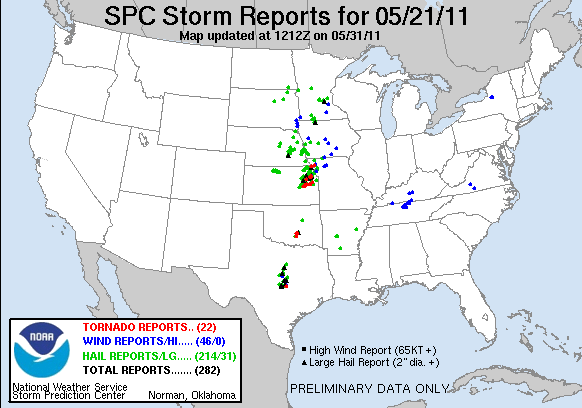
And the storm reports for Sunday: 

Looks like May is trying pick up the pace to hold on to what it is historically known for. Sunday's events is already holding a record for itself. Not in the number of tornadoes or number of storm reports, but because of a tornado that struck a city with a population of over 50,000 called Joplin, MO. It took a direct hit with a very intense, unrated tornado that has so far killed 89 people as of the morning of May 23, 2011 making it the 21st deadliest tornado in recorded history. To get a better idea of the damage, go to http://www.buzzfeed.com/mjs538/devastating-pictures-of-the-joplin-missouri-torna.
With what happened yesterday should we expect something similar for today? As it is nearly impossible to predict an exact perfect setup as was seen yesterday, we can definitely predict whether things will be simliar. Unfortunately, things are looking like they will be similiar to yesterday, just in different areas. Here is SPC's convective outlook for today: 
The moderate risk over Oklahoma, SE Kansas, and SW Missouri holds the highest risk for tornadoes (10%) and hail (45%). This area also holds the highest percentage of significant hail. The other area of moderate risk holds a risk of hail as well (30%), with the possibility of it being significant, and a high chance of strong, damaging winds (45%). Keeping that in mind and looking at the NAM and GFS models, here is my forecast for severe weathering using the SVRPROB:

I have highlighted similar areas as SPC did, but I have noticed some important factors in severe weather in lighter shade of red areas that I will watch for because of multiple layers of lifting and very high CAPE values. Where I found areas of the most instability is where I have the high risk areas. These areas are located in an environment of high CAPE, little CIN, lifting in upper, mid, and low levels of the atmosphere, abundant moisture, and areas where the surface winds are nearly perpendicular to the winds in the mid-layers of the atmosphere. All of this pretty much brews up perfect conditions for long-lived tornadoes and large hail as long as no other factors prevent it from happening. Storms have already formed and dropped lots of rain over NE Oklahoma, extreme NW Arkansas, and SW Missouri which will prevent further severe development for the time being, but the areas I have highlighted in a high risk have not seen anything yet and still getting peaks of sunshine, which will only exacerbate the situation. The darker shades of red is where storms will likely develop overnite.
Overall, keep a sharp eye on the highlighted areas, esp. the ones in a high risk area in the SVRPROB and ones in the moderate risk by SPC. Stay safe and be alert.
No comments:
Post a Comment