Wednesday, February 29, 2012

City Forecast Discussion: Providence, RI

File:Providence RI skyline2.jpg

The second city of the national forecast contest took us to the capital of the smallest state in the United States, Rhode Island.  Providence was a great and unique experience as all forecast cities have been so far.  The precise spot that was forecast for in Providence was at T. F. Green State Airport which The Rolling Stones were arrested at in 1972.  That was a little history for you.  Now back to the challenges in forecasting for it.  One of the biggest influences was the direction of wind.  If the winds came from a westerly or northerly direction it heated or cooled with respect to the rest of the land.  However, if the winds came from the south or east then the temperature was influence by the temperature of either the Greenwich Bay to the south or the Providence River/Narragansett Bay.  Both bodies of water had a temperature ranging from 40 to 45 degrees Fahrenheit.  This would keep the airport cool during the days and warm at night if winds were strong enough.  Also, the winds had a tendency to be strong at times due to them being next to the bays because of less friction on the wind than winds coming from Connecticut or Massachusetts.

Clouds always play a factor in any cities high and low and even wind as the fewer the clouds the warmer it gets and the stronger the winds can be if the land is much warmer than the bays.  The more clouds the less the temperature could warm and the calmer the winds are since average temperature over land is close to the body of water.  If a front comes through with really cold air behind it that's a different story, you will have stronger winds there because of temperature differences.  Storms normally come from the southeast about this time of the year, but in a whole year they can come from the southeast, west, and even from the east.  This year has been warmer than normal for a lot of places which allowed for more rain than snow this year.  Providence was effected by this, but still got some snow and snow really makes forecasting for a high and low difficult due to various warming and cooling processes it can do.  Forecasting snowfall amounts is always a challenge because it really depends on how much melting occurs or how cold it is.

Now that Providence is done the forecast contest has moved to another city which is far more challenging than Providence due to a number of local effects, but the biggest one of them all is mountains.  This city's nickname is The Duke City, known world wide for its International Balloon Fiesta, and is the largest city of one of the states of the Four Corners.

Wednesday, February 15, 2012

City Forecast Discussion: New Orleans, LA

File:New orleans montage.jpg

The beautiful city of New Orleans, well known for Mardi Gras, Bourbon Street, and Audubon Zoo.  Also, well known from it huge impact from Hurricane Katrina.  Amongst tropical system impacts, day to day basis weather forecasts are not as easy as it may seem for a city in a bowl.  The temperatures are highly influenced by both the Gulf of Mexico and Lake Pontchartrain and if the wind is blowing off either body of water.  If the water is blowing off either body of water it will keep temperatures warm during the day and at night.  However, if the water is blowing too strong off Lake Pontchartrain then the water temperature won't affect the air temperature very much.  As far as precipitation goes, it's a lot like Miami, FL with the exception of being affected by two sea breezes.  At this time of the year sea breezes were not much of a factor as fronts were.  Even with fronts it was just a matter of it rained over your location or not and the amount varied from place to place.

Challenging city for forecasting as wind plays a huge factor in a number of things and the two bodies of water play a very important role as well.  The next city is familiar with cold winters and a lot of snow.  It is known as the Beehive of Industry and the Creative Capital.  Located in the heart of The Ocean State.  Can you guess what it is?

Thursday, February 2, 2012

Exciting Start to 2012

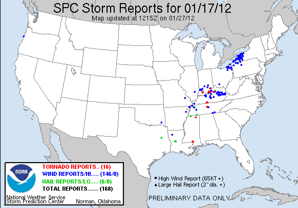
January 2012 is already starting off with a bang.  So far there has been 690 storm reports for January this year which includes 110 tornado reports, 469 wind reports, and 111 hail reports.  Of those tornado reports at least 82 of them are official tornado touchdowns.  Here are a few images of some of the most active days in January from SPC storms reports: 
120117_rpts Reports Graphic

120122_rpts Reports Graphic

120125_rpts Reports Graphic

Pretty fascinating to have such an active month in the middle of winter, but how does that add up to 2011 which ones one of the most active severe weather years in history.  The number of storm reports for January 2011 are 101 which including 10 tornado reports, 79 wind reports, 12 hail reports.  Of those tornado reports at least 1 is official with the possibility of adding about 3 or 4 more from a small Florida outbreak.  When doing a comparison between January 2011 to January 2012 there have been almost 7 times more storm reports for January 2012 than January 2011.

So, is this a precursor of an active year like 2011 or maybe more active?  Hard to say right now and far too early to tell, but it is noticeable that this year is starting off much warmer than last year with shots of cold air hitting the Southeast region.  February is starting off active like January so we shall see how things go.

Tuesday, December 27, 2011

Nature's Past New Year Shows and Forecast

2011 is coming to an end as New Year's Eve approaches and shortly after the infamous 2012 begins.  Your 2012 forecast is that everything you have seen about the world ending is true.  Just kidding!  Even though the Mayan calender ends on 2012 it is unlikely that the world would end.  What we can look at is how other years have ended and began.  Going all the way back to 1947 where the 1947 New Year's Eve Tornado Outbreak occured.  A year that ones during that time will never forget for the end of 1947 and the beginning of 1948 where 11 tornadoes tore through the Southern U.S. and unfortunately taking 256 lives from entering 1948.  On the bright side, 20 people were spared with injuries to live to tell of the great devastation.  Now moving to a much more recent tornadic event in 2010 when the 2010 New Year's Eve Tornado Outbreak occured in Oklahoma, Arkansas, Missouri, and Illinois from Dec. 31 to Jan 1.  As many as 36 tornadoes touched down with the strongest being an EF3.  Unfortunately, 9 lives were lost from this outbreak, but due to the vast advancements on tornado warnings and preparation ONLY 9 lives were lost and not large numbers like in 1947.

Now you are probably expecting a list of blizzards on New Year's Eve or New Year's Day.  Well, as far as recorded history shows there hasn't been any and the same thing goes for significant Nor'easters, but tropical systems is another story.  None have made landfall during this time here in the U.S., but it is always good to notify that hurricanes and tropical storms do exist around that time of the year.  Back in 1954, a storm in the Caribbean Sea developed and eventually became a hurricane known as Hurricane Alice and passed over the Leeward Islands.  It developed on Dec. 30, 1954 and died of on Jan. 6, 1955.  Almost exactly 51 years later another storm developed on nearly the same day as Hurricane Alice did.  During the historic and memorable 2005 season a storm developed on Dec. 29, 2005 and developed into Tropical Storm Zeta, the 30th named storm of that season which is record for the most tropical cyclones in a hurricane season on record.  Tropical Storm Zeta caused no damage to islands as it was a fish storm.  It eventually died off on Jan. 6, 2006.

It is known that New Year's Eve and New Year's Day are not really recognized as a holiday where great weather events occur, but as you have noticed anything is possible regardless of what time of the year it is.  What kind of weather will New York City have when the ball drops to end 2011 and begin 2012?  It is a far forecast, but for those who want to travel to Manhattan and stand in Time Square to see the beautiful 11,875 pound, lighted, crystal ball to drop the weather won't be too bad.  So far it is looking to be in the upper 30's when the ball drops at midnight with partly cloudy skies and winds coming from the NW at around 5 mph.  New York City isn't the only location in the U.S. that is dropping something though.  I have read of foods, fruits, musical instruments, leaves, shoes, disco balls, animals, flowers, jugs, sea creatures, beach balls, and many, many more things to drop at midnight in a number of locations around the U.S.  If you want to know more about it and what they are, go to the following link and find out.  http://en.wikipedia.org/wiki/List_of_objects_dropped_on_New_Year's_Eve

Sunday, December 25, 2011

The Spirit of Christmas Past


A Merry Christmas to everyone of all nationalities and all locations.  Some of us had a beautiful white Christmas with falling snow and/or snow on the ground and some of us didn't, but since this year what other sort of weather has people encountered for Christmas?  Not in any order of year, but in type of events that will be mentioned of the spirits of Christmas past.  Christmas in 1982 is known as the Christmas 1982 Tornado Outbreak for people in the Central-Southeastern U.S. as a system spawned 18 tornadoes from Dec. 23-25 with 3 lives lost.  Luckily, tornadic events are not very common around Christmas time, but blizzard events are a little more common.  The North American Blizzard of 1947 sprawled snow all over the Northeast Region of the U.S. dropping as much as 26 inches of snow in Manhattan at Central Park.  Snow started falling on Dec. 25 and steadily and silently fell through Dec. 26.  As harmless as it sounds it left devastation behind by taking away 77 lives.  A much more recent blizzard event was the December 2010 North American Blizzard.  Considered as a historic blizzard dropped as much as 34 inches of snow in and around New Jersey.  It affected the entire Atlantic Coastline with showers and thunderstorms in Florida to blizzard conditions in the Northeast.  This was one of a few storms that had the rare phenomena of thunder snow in it.  Was Jim Cantore there I'm not sure, but if he was he probably would have reacted like he did in early 2011 when he experienced it in Chicago. 


Amongst the nearly 3 feet of snow that was dropped and the howling winds that came along with it, this blizzard caused a pretty penny worth of damage rounding to $60 million and left behind 7 to perish.  It originated on Dec. 22 and didn't finish causing havoc for the U.S. until the 29th.  Other notable storms was the Christmas 1994 Nor'easter that formed Dec. 22 and ended on the 26th.  No snow or ice was reported from this storm, but it intensified rapidly to an amazing 970mb storm creating problems from the Southeast to the New England area.  Southeast experienced heavy rainfall with over 5 inches of rainfall and windy conditions along the Atlantic Coastline causing massive beach erosion from the Carolinas to Massachusetts.  More than $20 million of damage was caused by it and 2 lives were lost, but luckily no other lives were taken.

This is a list of some of the most memorable weather events on Christmas.  As weather recording has only be going on for abour 150 years for most places a lot of events cannot be taken into account and ones that were small but leaving big impacts on families were included either as they hard to track down.  I hope everyone has a Merry Christmas regardless of where you are.

Thursday, December 15, 2011

City Forecast Discussion: Erie, Pennsylvania

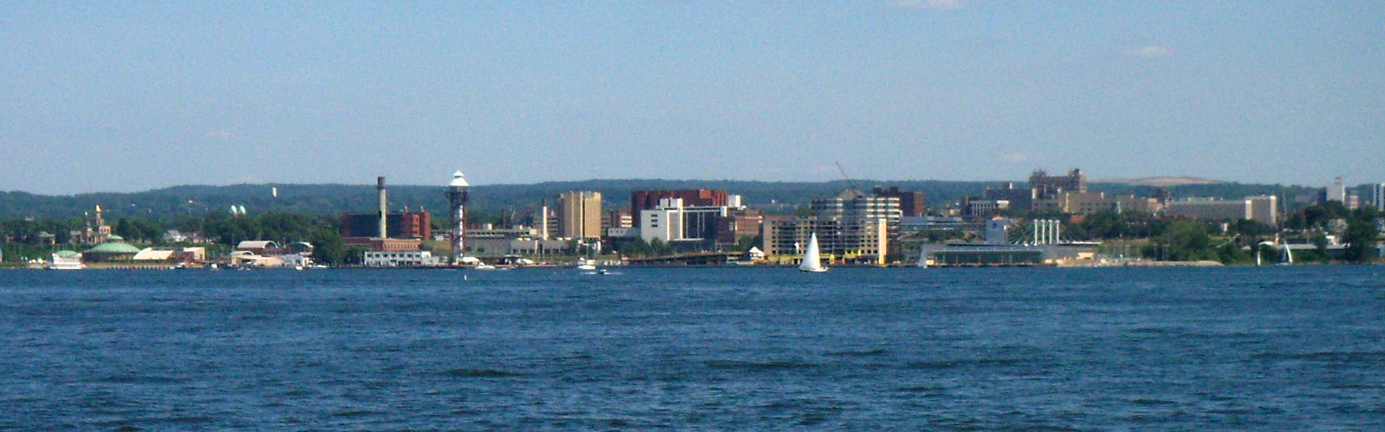
File:Eriesky2.jpg

A city that sits in the Northeast right on Lake Erie is the beautiful city of Erie.  A peaceful city with an old-fashion sense to it with beautiful country sides and beautiful neighborhoods.  Too bad the weather cannot be explained the same way.  Erie is as tricky as Miami and Juneau for forecasting since it sits right next to a body of water.  Every factor in the air plays an important role in determining how warm, cool, windy, dry, or wet it will be.  The temperatures for the city is highly dependent on the wind.  An important thing to keep in mind for Erie is that the highest sustained wind for each day is rather uncommon to go below 10 mph.  If the wind blows from the land to Erie it will warm up and cool off as the rest of the land warms and cools.  When the wind does this it has been noticed that Erie will reach its warmest and coolest days.  If the wind blows from Lake Erie then its a different animal.  Erie will have more of a small temperature change with winds blowing from the lake since before winter really kicks in it stays unfrozen.  From experience, there was a day where the high reached 41 and the low was 38 with the wind coming off the water that entire day.  That is only a 3 degree temperature change for an entire day.  Quite crazy.  Clouds were in the area, but the clouds primarily affect the temperature of the city if the wind is coming from the land blowing towards Erie.  Clouds have little affect when the wind is from the lake.

Precipitation amount is just as challenging as the high and low for Erie.  It boils down to how far north or south the low pressure system is, how cold the air is, and the direction it is moving with respect to wind.  Because of Erie's location it typically gets a piece of most systems that near it, but sometimes a low pressure system may not be near it and they will still receive rain or snow.  How is that?  An interesting phenomenan called lake effect.  It can be in the form of rain or snow, but most of the time it will be in the form of snow.  Snow is a funny and tricky form of precip to forecast for.  Not really in its form, but how much will fall and converting it to liquid.  Typically, you can use a 1:10 ratio meaning for every 1 inch of liquid water there will be 10 inches of snow and vice versa.  This however does not always follow through as it can be as little as 1:5 or as much as 1:50, figuratively speaking.  If this isn't tricky enough then keep in mind that if there were lake effect snow or rain it doesn't mean it will fall over Erie.

Finally, the wind is always hard to predict no matter what city you are in, but Erie is a little different.  Wind from bouys in the lake can be as high as 30 to 40 mph sustained, but just on land it could be 10 to 20 mph all due to friction.  The Erie International Airport is very close to Lake Erie, but there is still enough land to create enough friction with the wind to slow it down some.  For the short period of time that Erie was forecasted for the wind ranged from 13 to 22 mph depending upon how tight of a pressure gradient there is and whether the wind is coming off the water or land.

Overall, very tricky forecast city with the 2 weeks spent on it which allows for high respect for the meteorologists forecasting for the area.  Now Christmas break is in session and will have a resting period until the next forecast city starts in late January.  Here is a hint: It is known as The Big Easy and not located in any county, but another kind of geographic subdivision of a state; well known for a French phrase that occurs on a Tuesday every year before lent starts; and well known for a very famous street that has the same name as a type of whiskey.

Thursday, November 24, 2011

Thanksgiving and It's Weather Past

Happy Thanksgiving everyone.  Today in 2011 marks the 390th anniversary of celebrating Thanksgiving here in the United States.  This Thanksgiving has started out to be a fantastic day to celebrate around the United States, but it hasn't always been that way.  One memorable Thanksgiving event was all the way back in 1898 on November 26.  There were two strong low pressure systems that combined and created a terrible winter storm in the New England region.  The amount of snow that accumulated isn't well known, but the death tragedy was high in numbers.  A completely opposite event occured in 1922 on November 25th and 26th where there was a tornado outbreak in the southern U.S. known as the Late-November 1926 Tornado Outbreak.  There were an estimated 47 tornadoes reported that caused devastating damage and changed the lives of thousands of people as some perished and some were injured.  In 1950, the eastern U.S. experienced one of the worst winter storms in history on November 24th and 25th.  Some places received as much snow as 30 inches with winds gusting over 100 mph!  On the other side of the U.S. in 1983 there was a damaging windstorm that spand from November 10th to the 24th.  Wind gusts as high as 63 mph in some areas and downed power lines and trees causing widespread power outage for Thanksgiving in the Pacific Northwest part of the U.S.  The next day on the 25th in the same year a memorable storm produced more than 20 inches of snow in Colorado and began an unusual and unique stretch of day to day snow until January 27th, 1984.  In 1993, Texas experienced an unforgetable Thanksgiving Day not primarily because of the type of weather, but because of a sports event.  The Dallas Cowboys and Miami Dolphins played at the Texas Stadium with below freezing temperatures and sleet.  Due to a slip of a Cowboys player the Dolphins claimed victor for the game.  In 1994, a tornado outbreak sparked the day after Thanksgiving on November 27th when 19 tornadoes occured in the Southeastern portion of the United States known as 1994 Thanksgiving Weekend Tornado Outbreak.  The strongest tornado was an F3, unfortunately 6 people lost their lives.  On a brighter note, that is all that lost their lives on that day.  Another post-Thanksgiving tornado outbreak was the Arkansas-Mississippi-Alabama Tornado Outbreak when 67 tornadoes spawned in the 3 states that resulted in some loss of life with the strongest being three F4 tornadoes.  In 2005, the 'Blizzard of 2005" tracked as much as 20 inches of snow and 2 inches of ice in certain places in South Dakota and Minnesota.  No loss of life, but tens of thousands of people were left without power on Thanksgiving.  To finish up the list is a pre-Thanksgiving weather event that caused coastal flooding and damaging winds to people in the New England region.  At the same time, some of the earliest recorded snow along the Atlantic coast of Georgia and South Carolina.

These are only some of the memorable weather events that could be found without deep research.  Since Thanksgiving has been celebrated for almost 400 years it's hard to keep track of every event that occured.  One thing is for sure though.  The weather that was experience on the first day Thanksgiving was celebrated is nearly impecable to what it looks like now in the U.S.  When the English settlers and Wampanoag Indians gathered for Thanksgiving they enjoyed 3 straight days of nice weather which was perfect since their Thanksgiving feast lasted that long.  Look at the current radar for the entire United States.
Doppler Radar National Mosaic

Besides parts of California, Western Washington, and a some patches of snow in Oregon, Idaho, and Montana and spoty showers in Southern Florida this could look fairly identical to what was experienced 390 years ago.  Expect most of the places with no precipitation around them today to persist for almost 3 days.  Happy Thanksgiving!!

If you would like to look at some of these events in more detail visit this website.  http://www.earthgauge.net/wp-content/EG_Thanksgiving%20Weather.pdf