Tuesday, February 8, 2011

Southern Winter Event February 9-10, 2011

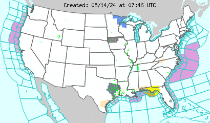
The Southeast is staring down another snow event that seems more promising of having a decent amount of snow to accumulate.  Giving the fact that below freezing temperatures have been reached every night for a while it is likely that snow will accumulate instead of melt.  I will give you a breakdown of all that will take in effect with this event and give you a better idea on whether the amount of snow forecasted will happen or not.  First, I will show the current watches and warnings for the U.S.  This image displays watches, warnings, statements and advisories issued by the National Weather Service

Now I will show you forecasts from various National Weather Services.  I will only keep this to a small area for time and space.  Here is what Jackson, MS is saying for central MS.  Snow Potential - Click for more information.

The snow forecast from Birmingham, AL for central AL.  Snow Potential - Click for more information.

The snow forecast from Huntsville, AL for nothern AL. 
Total Snowfall - Click for more information.
Snow forecast from Nashville, TN for central TN.  This one was strange.  Wednesday Snow - Click for more information.
Finally, snow forecast from Memphis, TN for western TN, northeastern Arkansas, and northern MS. 
Looking at all of these could create some complications because end at certain county lines and if you live on a county line where one NWS says you will get a certain amount of snow and the other that is close to you says something else then it can be confusing.  For example, Starkville, MS, home of MSU, shows an accumulation from Jackson to be 2-3 inches.  From nearby Memphis NWS viewing area it looks like Starkville could get 2-4 inches.  Then nearby Birmingham NWS viewing area shows that Starkville could get 1.5-3 inches.  Three different amounts from three nearby National Weather Services.  The safe bet would to take the lowest and the highest and there is your range of snow accumulation.  For Starkville, 1.5-4 inches.
Now to go into the science part of the possible snow accumulation.  Currently there are below freezing temperatures for most of the Southeast up to about 16,000 ft. in the atmosphere except for northern AL, MS and all of TN.  The NAM, a forecast model, shows the air becoming colder and colder as we continue through Wednesday and by the time the moisture gets to the Southeast the air will be around freezing and continue dropping giving the Southeast a better chance of snow.  The precipitation should start falling between 12pm and 6pm for all of MS and will continue to move towards the east from there.  Between these times the northern half of MS will see snow and the southern half will see rain mainly.  The same situation stands for AL, but at a later time, between 6pm and midnight.  The snow will leave MS by 6am Thursday morning and AL by 12pm on Thursday.  All times are central time.  Keep in mind this is only one forecast model and models only give you ideas on how things will go.  Now for the GFS.  The GFS, interestingly, holds the same idea as the NAM which doesn't happen very often.  What's even more unique is that the HRW, another forecast model, agrees as well with the timing.  The amount is the tricky part.  From the HRW, the MS, Arkansas, and LA border near Greenville could see no more than 4 inches and the amounts go down from there to the extreme northeastern part of MS where they could see up to an inch.  The HRW doesn't go far enough to figure out the totals for AL and TN.  The NAM shows as much as 3 inches for all of central MS to northern MS, no more than 3 inches for all AL except east central AL which could see up to an inch and all of central and western TN could see up to 2 inches with the except for the northwest part where an inch could be seen.  The GFS shows that central MS could see up to 2 inches and as little as a half of an inch in the northeastern part of the state, central and nothern AL could see between 0.5 inches of snow to an inch, and most of central and western TN could see around an inch.  Given these possible outcomes, the GFS seems to be underestimating the amount of snow, but once again these are just models to give people an idea of what might happen.  With all the models put together, MS could see between 0.5 to 4 inches, AL could see between 0.5 to 3 inches, and TN could see between 0.5 to 2 inches.
This is an overall breakdown and synopsis of what is going on and the possible outcomes of the whole event for MS, TN, and AL.  The forecast can always change because the event hasn't occured yet for those areas, but this is a good estimate.  I will keep you posted and updated for any further changes.  If you want any details about a specific location, for timing, or anything else let me know and I will provide it to you.

Thursday, February 3, 2011

February 3-4 Southern Winter Storm Event

The South is now under the gun of a winter storm event.  It will be nothing like the one a few days ago that completely shut down cities from Oklahoma through Illinois, but for the south it doesn't have to be anything like that to shut us down.  There is a winter storm warning stretching from Brownsville, TX all the way to Tupelo, MS and even some northern counties in AL.  It stretches all along the Texas coast and goes as far inland as Bryan, TX and Lukin, TX.  Here is an image to show where it's at and what else going on.  This image displays watches, warnings, statements and advisories issued by the National Weather Service

This is what is going on currently.  If you would like to follow it then use this link http://www.weather.gov/.  This storm system has been kept out of the "hype" of the media and weather associations which could or could not mean something.  What has caused this phenomena to come so far south is the upper level trough in the upper atmosphere.  It has pushed passed El Paso, TX and Del Rio, TX into Mexico with a lot of cold, Arctic air and is moving air towards the northeast where the Southeast states are.  Now this doesn't mean much unless we have something there to give it meaning.  In this case, we do have a lot going on that makes this important and the biggest part of that is below freezing temperatures.  The main focus for us when it comes to the weather it what is closer to the surface.  The interesting thing about this system is that the below freezing temperatures are north of most of the moisture and precipitation in the mid levels of the atmosphere and yet a lot of locations are reporting freezing rain and sleet.  This automatically dictates that the reason why this type of precip falling is because of a thin layer of below freezing temps that are freezing it either on the ground or before contact on the ground.  But right now is not as important as 6, 12, or even 18 hours from now.  Looking at a few models that can be handy in forecasting they are showing some interesting information.  The NAM is showing the heaviest of the precip is going to come through 3 AM to 12 PM CST for Mississippi and Louisiana.  It will leave Alabama around 6 AM CST Saturday morning and Georgia later than that.  The GFS, another model, is agreeing with the NAM to a point.  The GFS shows more intense precip before those time periods and heavier precip in Alabama and Georgia.  I could show you some images, but I like to keep it in a way where everyone can understand this and not some.

Keep in mind that from this point on until the late morning hours conditions will continue to deteriorate from Texas to Mississippi.  Ice accumuluations are most likely to average around a quarter of an inch in southern and central Mississippi, central and northern Louisiana, eastern Texas, western and central Tennessee, and central Alabama.  Some places could reach to higher accumuluations up to nearly a half of an inch.  A quarter of an inch already paralyzes a city/town, but more than that could really cripple one with large power outages.  Snow accumulation from this system will be in southeast central and southern Texas, northern Louisiana, southern and southeastern Arkansas, and northern Mississippi.  Accumulations of snow would be light but a maximum measurement of 3 to 4 inches primarily in Texas.  Smaller amounts in southern Arkansas and northern Louisiana and even smaller amounts in northern Mississippi and western and central Tennessee.

This is all a forecast as detailed as can be with as much accuracy as possible.  The weather is like a body of water and it always changes so things could be worse or they could be better.  Time will tell in this kind of situation esp. in the southern states, which are harder to predict for wintry weather than the northern states.  If you have an y requests or questions or concerns please notify me and I will do all that I can to answer and/or clarify anything.  Please remain indoors as bridges and over passes have ice on them and will continue to freeze throughout the night and roads will likely become in bas conditions.  If you have to travel, go slow, pace yourself, keep your distance from other drivers, and be safe.

Wednesday, February 2, 2011

METAR Mike's Blog: Historic Blizzard Event Outcomes

METAR Mike's Blog: Historic Blizzard Event Outcomes: "The low pressure system that swept across the eastern part of the U.S. was truly a historic event. There were several records broken, ..."

Historic Blizzard Event Outcomes

The low pressure system that swept across the eastern part of the U.S. was truly a historic event.  There were several records broken, but not any of them were in the South because it was all rain and thunderstorms.  The records were made in the snowy part of the low pressure system.  I will address the reported maximum amounts of snow located in each state and mention what locations have had record snow amounts:

Texas - 6 inches in Roby, Sweetwater, and Clyde.
Oklahoma - 21 inches 6 miles east of Owasso near Valley Park.
Kansas - 19 inches in Fort Scott.
Arkansas - 14 inches in Sulphur Springs.
Missouri - 23 inches in Warrensburg.
Nebraska - 6.9 inches in Omaha.
Illinois - 22.5 inches with a total of 24.5 inches on the ground 5 miles north-northeast of Addison.
Iowa - 17.5 inches 1 mile southeast of Keokuk.
Indiana - 17 inches 4 miles east of Chesterton.
Wisconsin - 20.5 inches in Middleton.
South Dakota - 10 inches 1 mile south of Brookings.
Minnesota - 11.6 inches in Pipestone.
Michigan - 18 inches in Hudsonville.
Ohio - 9.25 inches in Napoleon

Now these are some pretty impressive maximum totals for these states and a lot of these states have new snowfall records that were broken either for a particular day or for the entire month from this amazing winter event.  There wasn't much said for ice, sleet, and freezing rain totals as they did not make as much of an impact as the snow did.  There were some places that recorded 2 to 3 inches of sleet and then however much snow accumulated on it or was accumulated prior to the sleet accumulation.  The other frozen precip. does not have a record amount to speak of like snow does.

The thing that all of these states and many more states are concerned about is the low temperatures.  The temperatures are extremely cold in the Great Plains states, but what is even more bone chilling is the wind chill.  Here are the current temperatures at this time for the U.S.

US: Current Temperatures

There are a lot of single digits and even some negative single digits.  Now this is how it feels outside with the wind chill.

US: Current Wind Chill

Some very very cold weather when most locations it feels like its in the negative single digits and even a small amount of locations are in the negative twenties!  Unfortunately, this is only the beginning of the cold temperatures and how cold it feels outside.  Here is the reason why.

This image displays watches, warnings, statements and advisories issued by the National Weather Service

You will notice that there is a light shade of blue from Wisconsin all the way down to the Texas/Mexico border.  This light blue is wind chill advisory and what this means is that the cold air and wind will combine to make it feel much colder than what it is.  This means that the current current temperatures and the current wind chill will be even colder in the early morning hours of tomorrow.  Keep yourself bundled if you have to go out in locations where the temperature is extremely cold.  Best way to prevent from frostbite or hypothermia would be to stay indoors.

Monday, January 31, 2011

Tuesday Severe Weather Event

Tomorrow is going to be an interesting situation for the Southeast.  A large part of the U.S. is already experiencing some phenomenal winter weather from the Great Plains to the Midwest states.  Here is an image of all that is going on right now with watches and warnings.  This image displays watches, warnings, statements and advisories issued by the National Weather Service

All the red stretching from the Chicago area all the way down to the Oklahoma City area are under a Blizzard Warning.  All of the pink that stretches from Massachusetts all the way down to New Mexico is Winter Storm Warning.  All of this is covering at least a third of the country.  Now this doesn't show the severe weather that I have been building up to.  The following image shows a convective outlook for tomorrow between 1200Z (6:00 am CST) Tuesday to 1200Z (6:00 am CST) Wednesday for the U.S.  SPC Day 2 1730Z Outlook Categorical

This shows that there is a slight risk of severe storms stretching from Houston, TX to Destin, FL and from Memphis, TN to the Gulf Coast.  This may seem very general at first, but this image can be broken down to express a better idea of what kind of weather the southern states could be experiencing with this next image.
 SPC Day 2 1730Z Prob Outlook

This shows the probability of these storms to be severe.  15% isn't a lot, but when you spread it over a large area that is being shown with a good chance of thunderstorms covering the entire area it could amount to some storms being severe.  Keep in mind this is all a forecast and is likely to change in area coverage.  Here is the current scenario to show a point of view of how things are already set up. 
The stationary front in the Southern Great Plains along with the dry line will be moving towards the Southeast and grab a lot of moisture from the Gulf of Mexico.  Here is a forecast image of what the setup of this amazing weather event will look like at 1800Z (12:00 pm CST) Tuesday.  Forecast valid Tuesday 18Z

It looks pretty messy which is expected out of a situation like this, but allow me to elaborate some.  Everything within the green lines is precipitation.  The symbols with a star, *, is snow; the symbol with the dot in the triangle is sleet; the symbol with the upside down triangle and a dot on top is a rain shower; and the other symbols that are ahead of the cold fronts that are hard to explain are thunderstorms.  The pink dash line indicates the freezing degree line where the temperatures behind it are below freezing and the temperatures ahead of it are above freezing.  Since I am mainly sticking to the southern states where the severe weather is, I will show forecasted rainfall amounts for 00Z Tuesday (6:00 pm CST Monday) to 00Z Wednesday (6:00 pm CST Tuesday). 
If you remember the area where the slight risk of severe weather is you can see that the amount of rainfall for the southern states will range from a half of an inch along the coast to as much as about 1.5 inches around Memphis, TN.  This is a lot of rain that will likely fall.  The final thing to talk about that is just as amazing as the precipitaion is the temperatures.  Here are the forecasted highs for the U.S. on Tuesday.  Graphic Forecast of Temperatures Across the US from the National Digital Forecast Database

The smooth green colors is the approximate location of the fronts.  Cold front is most likely going to stretch from south-central Texas into Arkansas and the warm front will likely stretch from northeastern Arkansas to eastern Kentucky with a stationary front curving down into northern Georgia and turning back into a warm front at the North Carolina/Virginia border.  Now with these really warm temps in the Southeast and the very cold temps pushing down into The Great Plains will create a powerful clash of warm air and cold air creating some strong to possible severe thunderstorms along the cold front.  Now look at the temps forecasted after the low pressure system pushes eastward.  Graphic Forecast of Temperatures Across the US from the National Digital Forecast Database

You can now see a lot of cold air covering about 70% of the country esp. behind the cold front.  This is the arctic air that was behind this low pressure system.  The frontal boundary that I mentioned before is now in Georgia and in the western portions of the Carolina's and does not have as strong of a temperature difference in such a short period of time as it did before and all the states, MS, LA and TX coast, are below freezing.  This just goes to show how impressive and how strong of a low pressure system this is.

This is just a general overview of what is likely to come for Tuesday into Wednesday.  As Wednesday begins to kick off I will update all the imformation as it starts to come in to keep everyone posted and up-to-date on what to lookout for.

Monday, January 24, 2011

Tuesday/Wednesday Winter Weather Event Forecast

Last week the big talk was what will happen today and Tuesday. As today arrived, the days and times of this winter event has changed and moved into Tuesday night into Wednesday morning. That being said, the main focus will be on the details of the winter event, as of right now, and a brief forecast for the rest of the week for the Southeast.

Since today, Monday, is almost over, the high and low will not matter now and will focus on what will happen for the rest of today. The skies will remain mostly cloudy for MS, AL, and TN and becoming partly cloudy in GA. As the day comes closer to an end, cloudy skies will be moving into MS and gradually moving into MS and TN. Rain will be moving into southwest MS and continuing to move towards the NE eventually covering southern and central MS and southwest AL.

Tuesday is when all of the weather fun starts. Rain will be scattered all over MS and AL around mid-morning when everyone is getting up to go to work and school. It will remain as a moderate rain throughout the day. The rain will start to move out of southern MS and AL by 7pm as it continues to move towards the northeast. Some wintry precip will likely start falling in northern MS as the day comes to an end. TN will likely start off by seeing mixed precip throughout the morning, turn into rain in the afternoon, and turn back into mixed precip in the evening to the late night hours. GA will begin to see statewide scattered showers in the late morning hours and will continue throught the rest of the day. The extreme northern portions of GA will likely see some mix precip. esp. in higher elevations. MS will see a high ranging from the low 40's in the far northwest corner of the state to the mid 50's along the coast with a low ranging from the low 30's in the northwest corner to the low 40's along the coast. AL will see a high ranging from the upper 40's in the extreme northeast corner of the state to the mid 50's along the coast and a low ranging from the mid 30's in the northern part of the state to the mid 40's in some central parts like Montgomery and along the coast. TN will see a high ranging from the low 40's along the Mississippi River to the mid-to-upper 40's along the AL border and along I-75 to the northeast cornere of the state and a low ranging from the low 20's in the extreme northeast part of the state around Bristol to the mid 30's along the MS border. GA will see a low ranging from the upper 20's in the extreme northern counties of the state to the upper 40's along the GA coast and a high ranging from the upper 30's in the northern counties in higher elevation to the mid-to-upper 60's in the extreme southeast part of the state.

Wednesday will be the day of Southeastern wintry precip.  This is the important and yet tricky part of the forecast because of the timing.  Here are some good estimate timings of the wintry precip. from beginning to end: central and northern MS - between 9pm Tues. to 9am Wed.; central and northern AL - between 2am Wed. to12pm Wed.; TN - 3pm Tues. to 3am Wed. for western TN, between 3am Wed. to 12pm Wed. for central TN, and between 3am to 9pm for eastern TN (depending on elevation where orographic lifting will extend the length of time); northern GA - 12pm Wed. to 6pm Wed. for northern GA.  Now keep in mind these are estimated times based upon current model forecasts.  The times prior the wintry precip will be all rain.  Now on to the temperatures.  The lows in MS will range from the upper 20's in the extreme northwest corner of the state to near 40 degrees F along the coast and highs will range from near 40 degrees F in the northern parts of the state to the mid 50's along the coast.  The lows for AL will range from the low 30's in the northern part of the state to the low 40's in the extreme southeast and coastal locations like Dauphin Island, Orange Beach, and Gulf Shores and highs will range from the low 40's in the norther part of the state and upper 30's for the higher elevations in the extreme northeast and mid 50's along the coast.  The lows for TN will range from mid 20's in the western part of the state to the low 30's in the southeastern part of the state (which will happen near midnight of Wednesday) and highs will range from the mid 30's in the northwestern part of the state to the low-to-mid 40's in the eastern part of the state.  Finally, the lows for GA will range from upper 20's/lower 30's in the northern part of the state to the mid-to-upper 40's in the southwestern part of the state and along the coastal edges of the state such as Tybee Island and the highs will range from the low 40's in the northern part of the state to the mid 60's along the extreme southeastern part of the state.

That pretty much concludes my forecast discussion for this winter event with great detail of the Southeast.  I will update this Tuesday Jan. 25th for further updates.  If you would like to have more details about a certain location and/or state then please let me know and I will gladly supply you with the information you want.

Thursday, January 20, 2011

Thursday Night/Friday Southeast Winter Event Update.

Previously I mentioned that things are just not adding up to make this a memorable snow event.  As the time has gotten closer to the actual event this is proving to be more true.  Here is the synopsis on it and the reasons why this is proving to be more of a rain event for most of The South.  Temperatures right now for The Southeast Region are ranging from the mid-30's in the northern portions of AL, MS, and GA to the mid-50's in the southern potions of the states.  A cold front is already in central MS and northern AL and continuing to push towards the east-southeast.  Precipitation is stretching from southeast LA thru southern and eastern MS thru central and northern AL and further north in central and eastern TN.  The snow is being experienced in northern AL and most of TN.  The rest of it is all rain.  What this is saying is that where the snow is being experienced is where the cold front has already passed through and sending in the cold air to allow the snow to fall.

Now to tell the reason why the wintry precip isn't going to be as far south as once forecasted.  There is a lot of cold air that is behind the cold front and will drop temperatures low enough for snow to fall, but most of the precip. is ahead of the cold front and gradually dissipating behind the cold front.  This means that most places in The Southeast, with the exceptiong of TN and northern AL, will just see rain and thats it.  Northern AL could see up to a half inch of snow and that is about it.  TN, however, could see as much as 3 inches in some places like along the Cumberland Plateau.  Some people might worry about ice accumulation like the last winter event we had in The Southeast Region.  Ice will not be a worry what so ever either because temperatures have been warm enough to keep the ground from freezing even with the falling temps. from the cold front.

Overall, have no worries for all the people in The South.  Rain will be all of your worries for tonight and into Friday.  Tennessee will see multiple school and business closures due the amount of snow likely to fall.  There will, however, be another winter event pushing into The South Sunday into Monday.  That is far enough in the future where there are a lot of uncertainties to it such as how far south the low pressure will push, where the freezing temperature line will be, and how much precip. of both frozen and liquid types will fall.  I will update more information about this next winter event as it gets closer.